Kilimanjaro (National Park): Climb the roof of Africa, the highest free-standing mountain in the world
Facts Kilimanjaro National Park:
- Founded in 1973, UNESCO World Heritage Site since 1987
- Highest mountain in Africa and highest free-standing mountain in the world
- Various accommodation options of different categories in nearby Moshi or in Arusha
- Size: 1,668 km2 = about the size of London
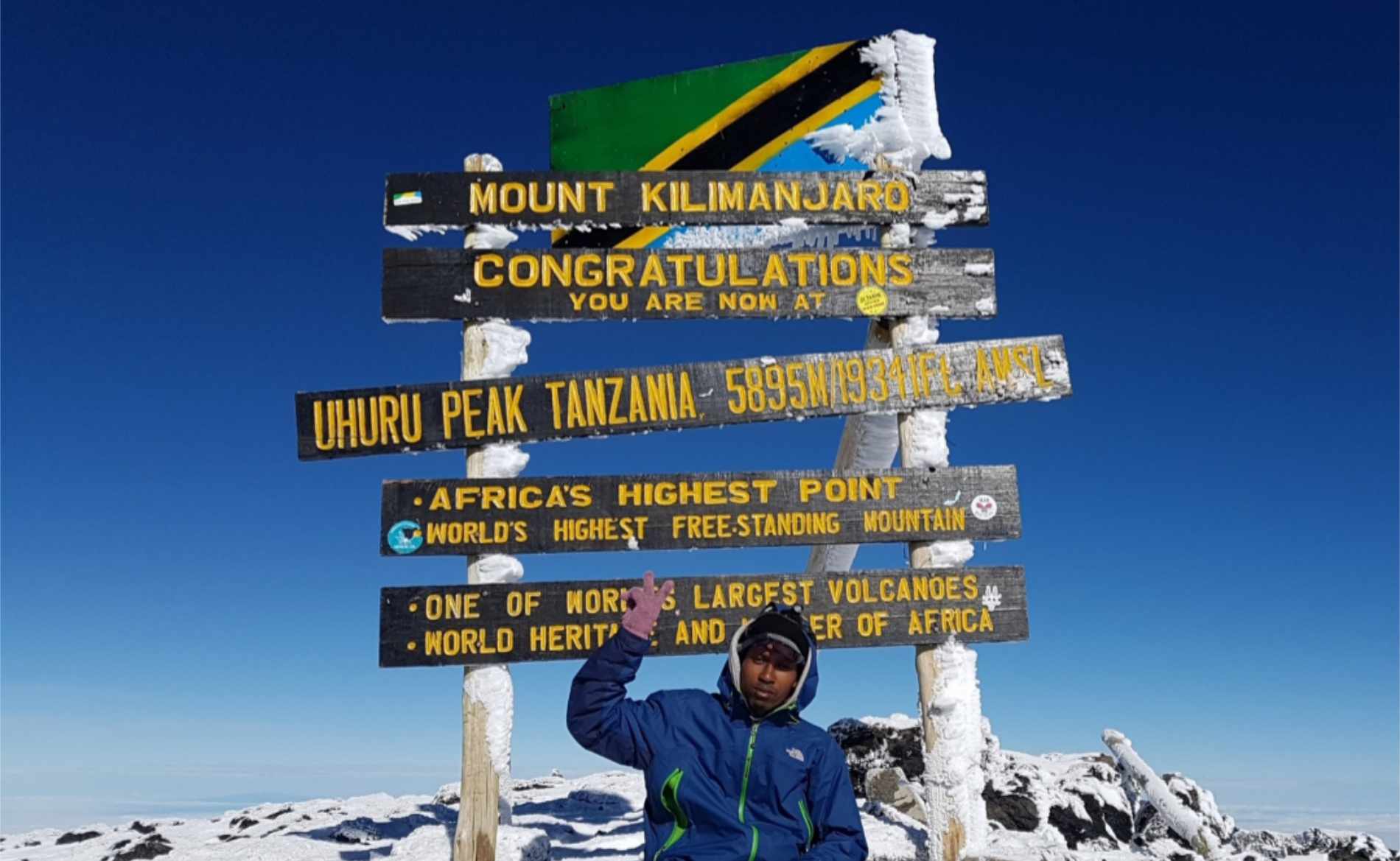
- Highest point: Uhuru peak 5,895 meters
Getting here from Arusha:
- Depending on which entrance is used, between 90 and 120 km, i.e. two to three hours’ drive
Highlights Kilimanjaro National Park:
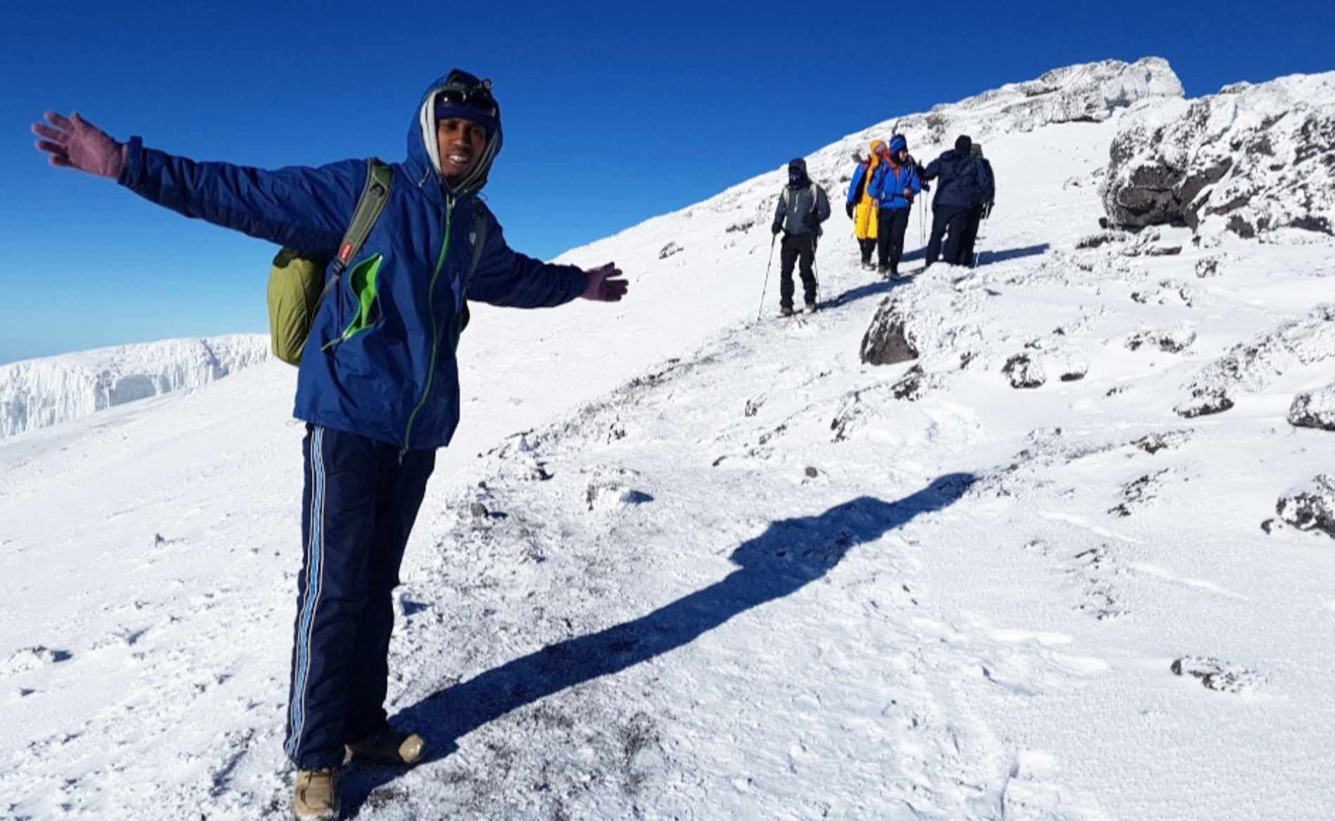
- Climb the mountain on one of the six different routes
- Enjoy the view of Kilimanjaro on a clear day
- Enjoy a cool Kilimanjaro beer, named after its big brother
Best time to visit:
At low altitudes with rainforest, you should always expect a shower, but of course there are differences in how often and how heavily it rains on Kilimanjaro. The climbing season can be divided as follows:
- During the summer season from early/mid-December to mid-March, you can plan an ascent very well. It is not as cold as in the Tanzanian winter and you generally only have to reckon with short showers. Due to their popularity, the treks also tend to be fuller.
- From mid/late March, the rainy season usually begins in northern Tanzania, which can make an ascent a slippery experience, especially on the southern routes. Until the end of May / mid-June, there are therefore few mountaineers on Kilimanjaro, which is a great opportunity for individual tourists to climb the mountain virtually alone. In addition, the chances of finding the summit covered in snow are high during this month, which is very scenic. An ascent via the northern and less rainy Rongai Route offers a good alternative during these months.
- The rainy season ends around mid-June, the weather becomes clearer and colder, offering spectacular views of the landscape. It is high season until the end of October, which is why you can expect more crowds, especially on the popular routes. This is of course the best opportunity to meet up with other mountaineers and motivate each other.
- November to early/mid-December is the short rainy season, which is why you should expect to get wet, especially in the rainforest zone. The weather gets warmer again and the sky is usually clear in the morning and evening.
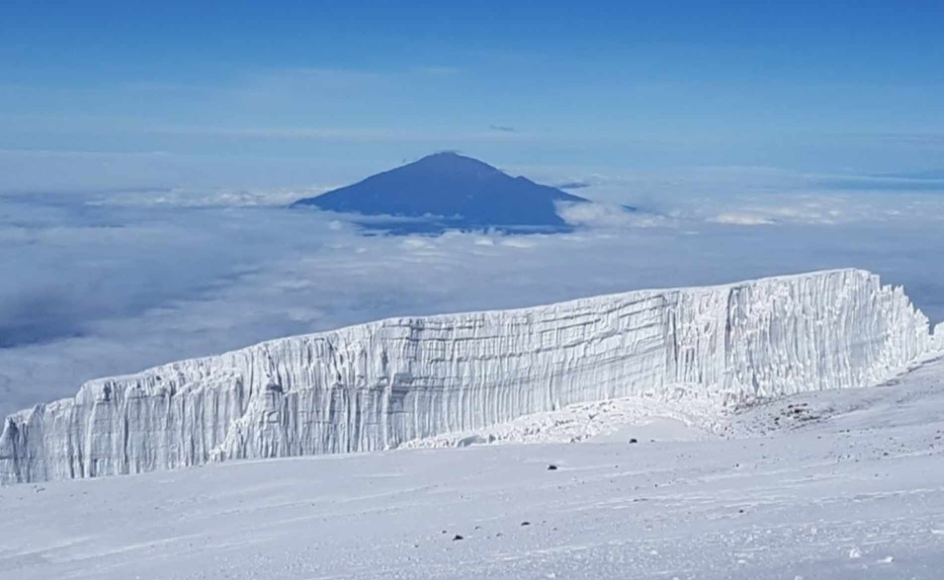
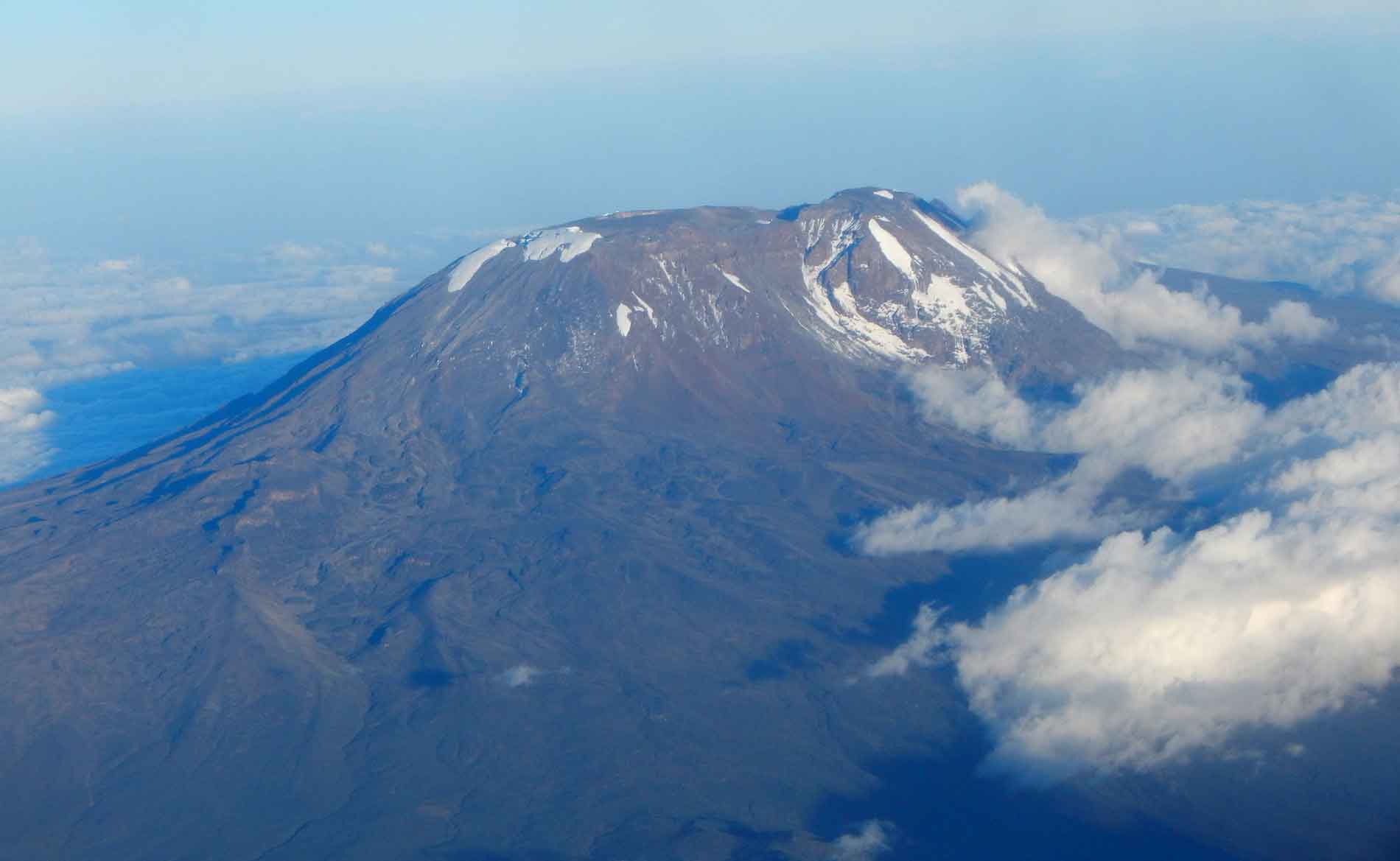
Of course, the name of the park comes from Mount Kilimanjaro. Also known as the “Roof of Africa”, it consists of the extinct volcanoes Shira (3,962 m) and Mawenzi (5,149 m) and the dormant volcano Kibo. Kibo is the only one with a glacier, which has shrunk to around 1.85 km2 in the last 100 years. Kibo has an approximately 24 km wide saddle plateau with an approximately 4.5 km2 crater, which was formed during the last activity between 150,000 and 200,000 years ago. On the crater rim is the highest peak, Uhuru Peak, at 5,895 meters above sea level. This makes Kilimanjaro the highest mountain in Africa and the highest free-standing mountain on earth.
There are various traditions about the origin of the name. The Chagga tribe lives at the foot of the mountain. One theory is that the name comes from their language, when they tried to explain to the German colonists that it was the “Kilemakiaro” – the most difficult mountain. Another possibility is the combination of the Swahili word “Kilima”, which means mountain, and the Chagga word “Njaro”, which roughly means white people. This would make Kilimanjaro the white mountain. The name of the highest mountain, Kibo, probably also comes from the Chagga language and was an astonished but also exhausted exclamation after reaching the summit. Uhuru means freedom in Swahili, which is probably related to the independence of Tanzania in 1961.
Kilimanjaro National Park is located around 150 kilometers or around two and a half hours’ drive from Arusha, near the town of Moshi. On a clear day, the view of the roof of Africa with its white blanket of snow and ice is breathtaking. From the base of the mountain to Uhuru peak, there are four climate zones, which is the equivalent of traveling from the equator to the Arctic. The vegetation and weather changes from rainforest (approx. 800 m – 3,000 m) heath and moorland (3,000 m – 4,200 m), alpine desert (4,200 m – 5,000 m) to the summit zone (over 5,000 m) with an arctic climate. The park is also home to up to 140 different mammal and 179 bird species. When attempting to climb Kilimanjaro, you can choose between six different routes.
- The Lemosho Route is one of the untouched and more difficult routes up Kilimanjaro. It starts in the northwest and begins lower than all other routes, which makes acclimatization easier and thus increases the chances of success. For this reason, the ascent also takes 7 or 8 days and makes the Lemosho Route one of the more expensive routes. During the hike, it offers great views and great diversity, but also challenging and steep passages, which requires a good level of fitness and surefootedness. After a few days, the Lemosho Route merges with the Machame Route, from where you are more likely to meet other hikers. On your descent via the Mweka Route, you will also get to see the south of Kilimanjaro.
The Machame Route in the southwest of Kilimanjaro is the most popular and hiked route on the ascent to the mountain. It offers the most varied vegetation and very good opportunities for acclimatization, as you hike high and sleep low. At the same time, however, it is steeper and therefore more demanding in terms of fitness than the Marangu Route, for example. This is why the Machame Route is also known as the “Whiskey Route”. In 6 or, for even better acclimatization, 7 days you spend the night in tents and your descent takes you via the Mweka Route in the south of the mountain. - The Marangu Route, also known as the “Coca-Cola Route” due to the opportunities to buy snacks and drinks along the way, is one of the most popular and shortest routes. The trail starts in the south-west of the mountain, leads through different levels of vegetation and offers wonderful views. The ascent is relatively moderate, but at the same time does not offer quite as good acclimatization opportunities, as you can only follow the “hike high and sleep low” guideline to a limited extent. The huts on the Marangu route are something special and provide more comfort with real beds than the accommodation in tents on all other routes. This can be an advantage, especially in the rainy season. The descent follows the same route as the ascent, which makes for a little less variety than on the other routes. For the Marangu Route, you need to plan at least 5 days, or 6 days to increase your chances of success.
- The Mweka Route lies in the south of the mountain and is the descent route for the Lemosho, Machame, Shira and Umbwe Route.
- The Rongai Route starts in the north of Kilimanjaro and leads via the summit of Mawenzi to the summit of Kibo. It is the only northern route of the mountain, has a longer approach and is less hiked than other routes. Due to its location, less rain is to be expected on the Rongai Tour, which is why it is not as green as others. Nevertheless, the area is beautiful and you have a great view of Kibo on the ascent. The route climbs steadily, but not too steeply. This makes the Rongai route one of the easier ones, but hiking high and sleeping deep is only possible to a limited extent, which leads to more difficult acclimatization. It is advisable to plan an extra acclimatization day for this. Shortly before the summit, the Rongai Route joins the Marangu Route, which is also used for the descent. All in all, you will need 6 to 7 days for the Rongai Route.
- The Shira Route is almost identical to the Lemosho Route, but it only takes 6 days. You save the extra day right at the start, which means a long and tough climb on the first day. Due to the sleeping altitude of 3,840 metres on the first day, acclimatization is difficult. However, once you get over it, it gets much better from day 2 onwards. The Shira Route also joins up with the Machame Route further up, from where you can meet more hikers. The descent is via the Mweka Route.
- The Umbwe Route is the most difficult route up Kilimanjaro and is only recommended for experienced mountaineers. On the first two days in particular, the climb is steep and over narrow, slippery paths. There are also climbing passages. Nature is at its most spectacular and untouched on the Umbwe route, which is of course also due to its infrequent use. You will reach the Uhuru summit in 6 days, although an extra day is also recommended here for better acclimatization. The descent is via the southern Mweka Route. Due to the direct route to the summit, the Umbwe Route is mainly used as a supply and rescue route in addition to being climbed by tourists.
If you just want to get a taste for a mountain climb, you can do a day hike on the first stage of the Marangu Route. There is also a good alternative for the less adventurous. According to the motto “If you can’t climb it, drink it”, you can enjoy a cold Kilimanjaro beer and, with a bit of luck, enjoy the view of the mountain that gave the mountain its name.